


BREAKING NEWS: HURRICANE DORIAN WORSE THAN EXPECTED
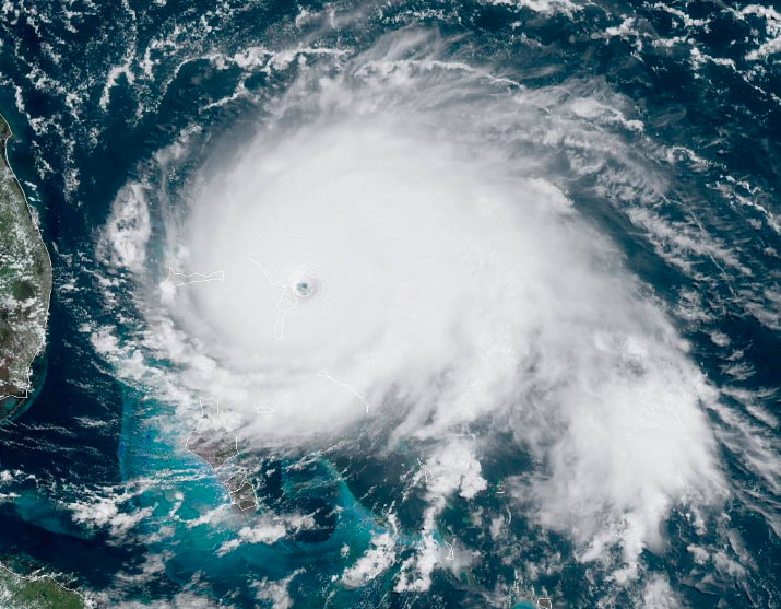
A satellite image of Hurricane Dorian over the Bahamas on Sept. 1, 2019.
September 1, 2019
Update 9/2/2019 11:05 am
Hurricane Dorian remains over the northern Bahamas and inches at a constant 1 mph towards the East Coast. The storm remains a category 5 and is expected to hover over Vero Beach and Fort Pierce area as a category 4. Those areas are already seeing tropical winds effects. Beachside Volusia county and most of the eastern coastline has mandatory evacuations in effect.
Seminole county schools have been closed through Wednesday, September 4th until further notice.
Original Article
The stirring of warm, Atlantic waters and the ever-changing climate have led to the recent development of stronger, and more dangerous, storms. In the midst of Hurricane season, Florida is expecting one of the worst in history: as Category 5, Hurricane Dorian inches its way towards the East Coast with potential to wreak havoc on Central Florida.
Earlier in the week, Dorian was promoted from a Category 1 storm to a Category 3, and its most recent developments are tracking Dorian as a ‘Cat 5.’ Florida is currently under a state of emergency issued by Gov. Ron De Santis. On Sunday morning, Dorian was seen moving a mere 8 mph over the Bahamas with winds up to 175 mph. Although different models are showing different paths, the basic track remains consistent: Dorian will approach the East Coast of FL as a Category 4 at least and may make landfall in the Palm Beach area. Whether the storm will make landfall or the exact location of landfall is still unknown. Dorian is expected to creep up the coast and lose some force as a Cat 3 as it tracks north.
Meteorologists predict that Dorian will bring 30 ft waves to the coast and expect winds to reach over 100 mph. Palm Beach County and Martin County are currently under Mandatory evacuations and Okeechobee, Highland, Hendry, and Glades counties are under Voluntary evactuations. Volusia county, specifically in New Smyrna and Daytona are taking serious precautions as well. Inland, storms are expected to bring Hurricane-force winds and several inches of rain. The strength of winds and rain in Central Florida is unknown, but government officials recommend to take extreme precautions.
Currently, schools in Seminole County will be closed through Tuesday, but that is subject to change. Many schools and safe spaces throughout Central FL will become Hurricane shelters. A full list can be found here.
Some last minute precautions that the State recommends include:
- have enough water for you and every person in your household to have one gallon per person per day
- make sure to store dry foods for consumption for you and your family
- if you or someone in your household needs prescription medications, be sure to have enough for several days
- keep flashlights, candles, and additional batteries with you in case power goes out
- remove large branches, flower pots, and furniture from yards and driveways to prevent flying debris
- boarding windows may be necessary in areas expecting high winds to prevent debris from shattering windows and glass
- identify a place in your home or apartment on the lowest level with few windows to stay safe in during the storm
Here are some local news channels to follow along for hourly updated information:
https://www.floridadisaster.org/info/
https://www.mynews13.com/fl/orlando
This article was last edited at 11:05 am on Sept. 2 by The Seminole Staff and information is subject to change. Stay tuned to local news channels and here for continuous updates.